New River Prairie/New River Strand Out to Sunday Bay
I just posted pictures from the epic kayak pull from Highway 41 south to New River Strand to New River.
My 2 friends Leanne and Scott and I did this trip in early 2000.
We pulled 2 days and on the 3rd day reached the New River Strand where the water was sufficient to support the kayaks. Eventually we were able to get in the kayaks and begin paddling.
In one of the isolate lakes that New River opened wide as, we observed what looked like archaeologic remains of an indian village - posts rotted off at the surface of the lake that looked as though they had once supported houses/huts out over the lake/river.
This was an amazing trip.
Views: 2055
- Attachments:
-
-
 Gr8NwRvrTrip.jpg, 244 KB
 -
14MangrovePullingNewRiverCreek.jpg, 2.2 MB
-
13BustingthrutoNewRiver.jpg, 1.7 MB
-
Replies to This Discussion
-
Permalink Reply by Chris H on
-
Very nice write up Shawn. It was definitely a very challenging but fun hike. The Pepper forest did look interesting and the location seemed appropriate. It would be interesting to explore that area more... although it could take days to thoroughly explore.
-
Permalink Reply by shawn beightol on
-
King was one of the Surveyors for the Jaudon and other land owners interested in developing Chevelier/Pinecrest and thus motivated to push the Tamiami Trail through.
This is an excerpt of a series on how he enjoyed his time with his son on their days off from 1919. It discusses his interest in finding Ft Harrell and references the "Old Jeff Davis' Map". Along with the Ives and Copeland maps, the Jeff Davis Map is considered one of the most accurate and authoritative. That map is below this article. Notice Ft Harrell is perhaps on a river that is more likely east of today's New River
-
-
-
-
Here's the map
-
Permalink Reply by Swamp Hunter on
-
They speak of a jaunt up Sweetwater River. I was told that it could be as far south as Deer Island but I didnt want to believe it.
-
-
Here is the link to the National Archives list of important Florida Maps and on the left sidebar, a menu to research other documents:
http://www.archives.gov/publications/finding-aids/maps/fl.html
this is the Library of Congress Map division: http://memory.loc.gov/ammem/gmdhtml/gmdhome.html
-
-
Apparently in 1918-1919, there were still remnants of the wooden barricade/wall visible to King's party:
"...now that the travelers were actually on the ground after a picturesque jaunt up Sweetwater River there was little to see save the solitude of hammocks and ground stretching away into misty perspective and ridges of rotted wood where once had been fortifications. They stood as a mute testimony to the ravaging work of time which brings all of man's creations at last to dust"
-
-
this article preceded the above (meaning, apparently his optimism of its intact-ness 75 years after it was built and then abandoned was wee bit over the top).
NATURE'S EGRET AVIARY CONTINUED FROM PAGE 335
Tomorrow said Mr King we will take the tender and go up to famous old Fort Harrell
There is a real expedition for you John
It was built with its stern log stockades immediately after the Seminole Wars
Soldiers were stationed there to keep the Indians from coming out
I have heard from Miami chiefs that there is much to see
Time has not disintegrated it
Mr King was also thinking of another side of the trip Across one of the passages in the direction of Alligator Bay ...
-
-
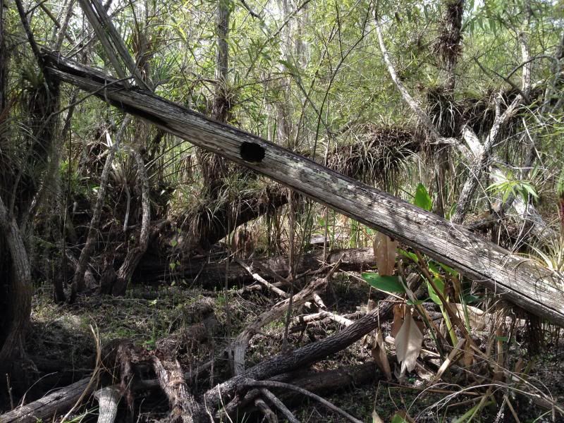
Chris sent me some cool pictures from our trip. It sure was dry. I didnt see any mudholes that I would have been willing to drink out of so it was probably a good idea I decided to carry extra drinks. It also seemed that every little mudhole looked like this with a resident gator that submerged upon our entrance.. You can see in this picture the moving water, also my bulging side pockets where I carried extra gatorade jugs. I didnt realize this would be such a problem but Im convinced it caused all my high leg and hip pain. Im slow to make changes but maybe its time I use a hydration backpack.
-
-
Anyone up for a "beeline" hike to the New River headwaters for another look around this saturday?
I'm really curious about searching the southern bank of the creek from the headwaters down about a mile - along the creek.
-
-
It was probablty true. Its common knowlege that traces of Fort Poinsett could be seen until the Labor Day Hurricane of 1935 crossed the Cape (Sable).
Maybe I could ask my Indian friends to ask the elders. Maybe they have some knowlege. I have a feeling some tribal members may trust me after living at FMB for the past 5 out of 6 seasons. Its a long shot but we shouldnt turn away any help and finding a Seminole War fort would be of interest to the Miccosuki Tribe as well..
shawn beightol said:this article preceded the above (meaning, apparently his optimism of its intact-ness 75 years after it was built and then abandoned was wee bit over the top).
-
-
I am interested in going back down this Saturday for a "beeline" hike to the headwaters of New River where we will hunt extensively along the south bank down toward the airboat trail. There are a couple clearings of interest to investigate. The round trip hike is 10 miles plus whatever we accomplish at the river.
This would not be a hike for casual hikers or "newbies." There are miles of hiking where there is no trail. Some areas are mucky. Lots of high stepping through grass.
Send me a message if you are interested in meeting out there at 730 AM Saturday morning. We will be back at the parking lot by 4-5 PM.
About
Welcome to
Everglades Exploration Network
© 2025 Created by Keith W.
Powered by
![]()