March 2011 loop trip
Finally got some time to post a short trip report of my 8-day March loop from Hell's Bay out to Willy Willy and back. I won't go into all the details and will focus on the first 3 days of the trip, where I accomplished a long-sought goal of finding an inside southern route that completely bypasses Whitewater Bay, and takes you through some of the prettiest backcountry creeks that nobody ever gets to see. I started at the Hells Bay trail dock and spent my first night at Lane Bay. The Google Earth screenshot shows days 2 (red line) and 3 (green line) of the trip. Day 2 started at Lane Bay and runs through the maze of creeks that Terry calls the Old Camp Route, and crosses Roberts River, North River, and ends at North River Chickee. Day 3 was the most challenging of the trip and followed a long, tortuous series of small creeks and bays we call the North Watson Route, which starts at North River chickee and comes out near the entrance of Watson River. The entire route from Lane Bay to Watson River was passable with deep water in the creeks and bays, and there were no significant obstructions of any kind. If there was ever a prime candidate for an Alternative Wilderness Waterway trail, this is it. Having a route that allows paddlers to bypass the open water of Whitewater Bay is a very nice thing and this will probably become my standard route for future trips along the eastern shores of Whitewater Bay. I will post detailed aerials of these routes in the near future, but you should be warned that they are not marked on the ground, and are for those who already have some experience in following charts and aerials without a GPS. If you're just getting started paddling the Everglades, then get some more experience before attempting these routes, at least until the ENP gets around to marking them.
The rest of the trip was pretty much the usual WW stuff. Day 3 ended at Shark River Chickee after a long westerly detour through the Labyrinth to Shark Cutoff, and back up the Little Shark River on the rising tide. Day 4 took me to Broad River via the Nightmare. Day 5 was Willy Willy via the Gulf and Lostmans' River. Day 6 was a bit more exciting, as I got caught by a strong cold front on my way down Rogers River to Highland Beach. 50 mph wind gusts threatened to tear loose the mangroves from the river bank where I was holed up while the front blew through. Day 7 was a wild ride down the Gulf coast from Highland Beach to South Joe River with a 25 mph NW wind screaming at my back while crossing Ponce DeLeon Bay. The wind raised 3 foot standing waves against the falling tide at the mouth of the Little Shark, and I got a little whitewater action there. The last day took me from South Joe River across the south end of Whitewater Bay back to Hells Bay trail, and the end of the journey.
Views: 1295
Replies to This Discussion
-
Permalink Reply by vivian on
-
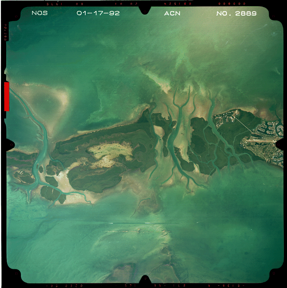
Here is my alternative route for the North River to Watson River chickee route. What do you think Keith, looks navigable throughout. Total mileage for this leg is only 7 miles.
-
Permalink Reply by Terry on
-
Yes, this route takes you to Watson River Chickee and breaks from Keith's route at
20.951'N and 57.668'W. You can also take the first left off North River at
20.139'N and 55.993'W. Keith went up to the second left for the extended
route. Any way you choose the North Watson Route is all good.
Don't forget the Old Camp Route between Roberts River Chickee and
North River Chickee and take the Maze from Lane River Chickee
to Roberts River Chickee - excellent. There's so much canoeing in
there it will keep you entertained for the rest of your life.
-
Permalink Reply by yakmaster on
-
"entertained for the rest of your life"...if you do it right...
travelling in circles for the rest of your life if you don't
These routes are not for the faint of heart or navigationaly challenged. Like it says in the commercials
"performed on a closed course by professional drivers, do not try this at home"
Not saying you shouldn't go there, just saying be a good scout & BE PREPARED!
-
-
Especially the Maze that seems to be the opposite of the Labyrinth.
Like the Labyrinth the Maze has only a few ways in but they are totally
different once inside. The Labyrinth fans out like our circulatory system then the
passages all seem to come back together to come out the other side. A compass
is all you need to follow a heading and you'll eventually come out.
Unlike the Labyrinth, once you enter the Maze the passages fan out into countless
smaller and smaller dead ends with only a couple that connect through. To make it
even trickier it doesn't show on the nautical charts making navigation
through it impossible without aerials. This is off the charts at it's best!
And how cool is it to go to Roberts River Chickee without using Roberts River.
-
-
I agree, after studying the aerials i almost ditched the idea of doing the route. I have explored many of the lake and creeks off of the main hells bay trail and know it is very confusing. Then add the lack of detail available to map this route on gps or even a nautical chart and that concerns me. Fortunately I found GPS Visualizer and was able to add waypoints and bearings to my aerial views and the gps for location verification,
Just in the last two years I began using GPS but have always felt comfortable with map and compass, plotting my routes before each trip. You need the aerials but also point to point navigation via compass bearings.
Keith did a fascinating trip and i plan to do sections of it. I prefer more of a variety in my route.
-
-
That's why this is called the Everglades EXPLORATION Network. (Keith, I still think we should restore the "Deep"! EDEN is so much better than EEN)
I think more alternative route information has been created and shared by the connections, synergies and exchanges on this site in the past couple of years than would have been generated through 20 years of traditional exchanges! And so much more is happening & being done because of it!
It's just important to be prepared. That means GPS, with paper backup. Map where you're planning to be & everything around it. And take it with you! That alternate route map that you created & left home don't do much for you when you had to reroute in the field (voluntarily or involuntarily...)!
I always keep an eye on the electronics (more than Terry thinks I should), but you never know when they aren't going to work, so you need aerials, and I recommend various aerial platforms in various resolutions. That little island in that little pond looks different in google earth & the black & white USGS pictures, & when you're zoomed in tight or with a wider perspective... so it helps to be able to look at a couple of different images to figure out WHERE THE HELL YOU ARE...& HOW DO YOU GET BACK?!?!?
Remember, the real secret ain't getting there...
It's getting back to tell the story
and if you can leave out the part of having to spend the unplanned evening sleeping in your canoe...it's even better... though it may make for a better story!
-
Permalink Reply by Xavier Becquer on
-
Hey the appalachian trail is blazed beginning to end by volunteers. From reading this thread it seems that this may be thee alternate to the normal ww high wind route. maybe it can be marked out similar to hells bay. The cost of PVC is very menial and would give a greater margin of safety for those who are navigationally challanged.
-
-
I recommend various aerial platforms in various resolutions. That little island in that little pond looks different in google earth & the black & white USGS pictures, & when you're zoomed in tight or with a wider perspective... so it helps to be able to look at a couple of different images to figure out WHERE THE HELL YOU ARE...& HOW DO YOU GET BACK?!?!?
Yakmaster, the beauty of that GPS Visualizer (free online tool) is that you can see the route in USGS, Google, etc just to verify areas that are difficult to get through. Here is the link again:
Go to freehand drawing tool and at that screen write the location (on left of screen) Flamingo, FL
Zoom in and use the waypoint tool to plot your route. Then save as a GPX file open in Mapsource then view in Google earth to verify and print trip aerials with.
I made a nice notebook showing waypoints in numbered sequence with bearings.
-
-
Absolutely, I had checked it out when you posted it last. It's excellent. I particularly liked that the yahoo map version gives a better view of Jones Lagoon (one of my favorite places) than what I was getting from Google.
What I'm saying is after you "visualize it" and load it into the handheld, it's important to print out those trail maps and stick'em in a ziplock...& bring'em along. Even if you don't use them...it's like GPS insurance!
-
-
That is by far the sweetest part of Biscayne National Park... Named after Parson Jones and his son Lancelot, the last resident of the Park. This is located between the bay & the ocean between Elliott & Key Largo. More specifically between Swan & Caesers' creeks...but the creeks south of there ain't too bad either!
Take you out when you want or the Park Concessionaire is doing 1 trip a month. This really should not be missed! The Bushpaddlers call it the black hole. It's a bear to find your way in...but it's even tougher to get out! Kinda like some of the other places we were talking about.
Which circles back to my point compare what I've attched below to the google version you can find on my site or in visualizer, or to the yahoo version in visualizer...it looks slightly different in each...& those differences can be the cue that helps you figure out where you are & where that exit is!
-
-
Speaking of Jones Lagoon, I've had a lot of requests for more guided
tours of Jones Lagoon, it seems the two last season went over really big.
I'll let you know Yakmaster, it will be soon after the first cool front.
I wonder what the 2011 Invitational will be.
- ‹ Previous
- 1
- 2
- 3
- 4
- Next ›
About
Welcome to
Everglades Exploration Network
© 2025 Created by Keith W.
Powered by
![]()