May trip - Gator Hook to Roberts Lakes Strand
Views: 17142
Replies to This Discussion
-
Permalink Reply by Swamp Hunter on
-
I took the liberty to google Zoltan Torok and he does some cool stuff. Click on FILMS for the short Everglades clip. http://wildtales.net/team/
-
-
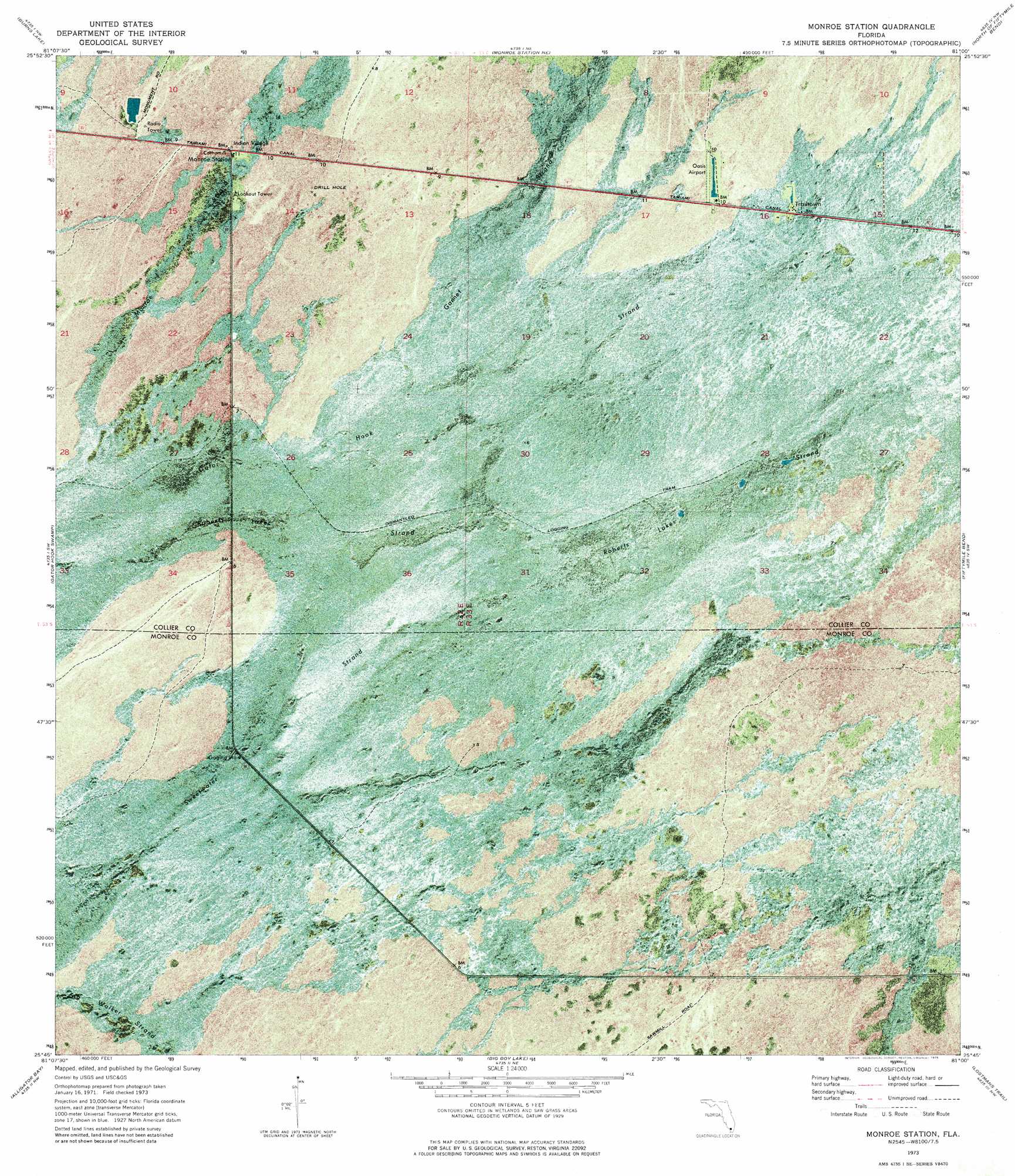
Here is a link to purchase topo maps. http://www.yellowmaps.com/usgs/quad/25081g1.htm Its the same USGS map I have been using since the late 70s before GPS technology. It was photographed in 1971.
Note "DISMANTLED LOGGING TRAM". http://www.yellowmaps.com/usgs/topomaps/drg24/30p/P25081G1.jpg Click on to enlarge.
The other trail was a logging trail to cut the large Dade County Pines.(SAWMILL ROAD) Later they became buggy trails. The NPS later stopped off road vehicle use in the Loop Unit. The FT has not yet been established.
The very far right bottom corner is the start of "Busch Camp Trail".
-
-
You may also notice the logging tram continues on the opposite side of the canal. It was a long time ago but I remember this part of Loop Road being almost impassable and my guess the canal was no more than a ditch. The map shows the difference in vegetation and the wide canal keeps this area a secret. I remember 2 old-timers used to hide a dinghy at the canals edge to cross into their secret area, unknown to casual passerbys. I no longer see these men. They may have passed on.
We need to cross this canal at some later date to explore and re-discover this abandoned tram line. I believe I was on it in the 70s with my ATC90 and the trail was nice and scenic running way into the deep swamp of Gator Hook, the trails namesake. Maybe the NPS will build us a bridge before its lost forever?
We have enough work to finish what we started but Im just giving you a little taste of a possible future exploration project. I have always said that a person could spend an entire lifetime exploring the region and never see it all! And I never get tired of it!
-
-
Heres the rest of the tram/trail going deep into Gator Hook Swamp. Clic to enlarge. http://www.yellowmaps.com/usgs/topomaps/drg24/30p/P25081G2.jpg
-
Permalink Reply by Dallas on
-
Dale, do you think this portion of the trail follows an elevated tram line as well?
-
-
I dont know. The trail I accessed on my ATC was not elevated but Im not even sure where exactly I was. I find it odd that its not apparent on Google Earth but the swamp can cover up a trail in a short time.. There must have been a lot of big cypress trees in Gator Hook.
My guess these 2 trails were connected at the current trailhead as the logs were taken to Reynolds Sawmill.
I was tempted to canoe down that canal (Loop Rd) last year from Monroe Station and check it out but its full of gators. We had a very agressive gator near the check station last season that used to chase away the people trying to fish.
-
-
I would like to mention that the west Gator Hook tram lies within the Stairsteps.. The trail itself seems to be the border line between Zone 2 and Zone 3 of the Stairsteps Unit.. Traditionally off-road vehicles were allowed in the Steps with dispersed use. Recently however off-road vehicles have been restricted to designated trails. It appears a well meaning environmental group didnt like what the dispersed trails looked like from the air even though the trails themselves actually benefitted all wildlife.
The compromise from the environmentalists lawsuits resulted in designated rock roads being built throughout the Stairsteps 1, 2 & 3, Turner River and Corn Dance Units. The rock roads allow vehicles to stay on one single trail. This also allows ATV access deep into the interior, never before possible. Many believe this compromise is much more damaging than the "dispersed use" trails. The rock roads are certainly more permanent, could divert natural water flow and may be impossible to maintain..
The point I am getting to is that these designated trails can be requested and if approved the NPS will bring in dump truck loads of rock.. Could it be that nobody requested this as a designated trail?
Is this what we want for the West Gator Hook Trail? I havent explored it yet but my gut feeling is no...not this trail. Just something to think about.
Dallas said:
Dale, do you think this portion of the trail follows an elevated tram line as well?
-
Permalink Reply by Chris H on
-
I wish I could make it March 30th but I have a busy weekend ahead. I did make it out last weekend though and had a great time. It’s a beautiful trail. It was very dry, hardly any water anywhere. The names you have given these areas (Gauntlet, Holey Rock, etc) are very fitting! On the way back I saw two cottonmouths and there was a gator lying in the trail between the Mask and Holey Rock area.
Dale said:Welcome Chris. Im glad to find others that are interested. I absolutely loved it last Saturday. I dont know if I can make it this Saturday but at least 2 of us are planning to go out Mar 30.
-
-
Thats probably the same guy I stepped on. It about gave me a heart attack. Cool pic.
-
-
Animals will often use people trails. Bob Hill told me that large Pythons are also ambush predators that lie and wait on trails.
About
Welcome to
Everglades Exploration Network
© 2025 Created by Keith W.
Powered by
![]()