River of Grass flows again into Everglades National Park
River of Grass flows again into Everglades National Park
A backhoe breaks through the roadbed of the old Tamiami Trail
Views: 2114
Replies to This Discussion
-
Permalink Reply by Amazon Bill on
-
I heard the US Army Corp is getting funding next year for raising the next 5.5 miles of Tamiami Trail up onto bridges. The other item under study is the refining of the hydraulic flow models so the prediction of canal water height to downstream depth and horizontal flow is more accurate.
-
Permalink Reply by Flex Kayakfari.com on
-
I like the sound of this!
Terry said:And have I got some plans for the up coming season!
Some of these trips for the 2013-14 season even
surprise me. We're gonna paddle where? How?
Can that be done? Mixed in with the old favorites.
And, of course, most will be black diamond or
double black diamond routes, paddling from
dawn to dusk. Stay tuned,
Saturdays starting in October.
-
Permalink Reply by Ted on
-
Below is a link to emergency measures SFWMD are taking to lower the water levels. Let the water flow
http://www.sfwmd.gov/portal/page/portal/xrepository/sfwmd_repositor...
-
Permalink Reply by yakmaster on
-
Guess the L-67 culverts weren't enough, so they blew the road!!!
Excellent, more water down the L-67, More water on Main Street!!!
When we paddled the slough in November, they had already made the cut, Here's Flex's picture of it.
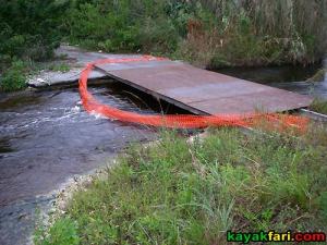
"This temporary culvert “creek” has been cut to allow excess water from WCA-3A to drain into the L-67 Ext canal pictured below. Water levels were unusually high with strong flow." said Flex back in the day
Before they made the cut we saw in November, it looked like this
Don't know if they're talking about the old cut, to make it look like they're proactive, or if the expanded the cut...
-
-
Went out to the L-67. It's open & FLOWING! Not to big a cut, but plenty of flow.
The bigger cut was the big bridge, all the road underneath has been removed, but they still have the floating booms in place. Wasn't able to get down low to see if it's flowing, and didn't get any pictures.
But I got some pictures of the little cut, you can see the flow. I was tempted to ride it south...but then you have to fight it north:
-
Permalink Reply by Swamp Hunter on
-
Rumor the water is flowing good down canals but not so much under the new Tamiami Trail bridge. Maybe its just rumor.
-
-
Well, the booms under the bridge are still up and the water (or wind, can't tell) has them up against the grass, so hopefully when they remove the plastic...the water will flow there too.
I was over by Chekika on Saturday and the water was pretty high, but not real high considering all the rain we've gotten lately.
-
-
What's interesting, if you look at the old aerial I posted a while back
They replaced the culverts with the new bridge, but they closed off the old bridge (over to the west) that they had before...
So they've increased the flow to the canal & reduced the direct flow into the grass
-
Permalink Reply by Terry on
-
The station to use for the top of Shark Slough is 02290862 (NP202)
which is where NP202 Hammock gets it's name. As mentioned before
you need to get to this is the hammock just off of L-67 to pickup the airboat trail.
Currently that station is at +6.75, just for reference, when you guys went down the slough
last November it was +6.50. Personally, I'd like to see a break in the heat then
it's paddle time.
-
-
Where is the aerial Yakmaster? Is that south of the Trail? Im going by that way today or tonite.
-
-
OK thanks
yakmaster said:It's on the south side of the trail at L-67 extension.
About
Welcome to
Everglades Exploration Network
© 2025 Created by Keith W.
Powered by
![]()