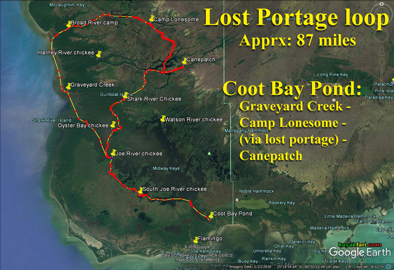
The Lost Portage is no longer Lost
Outward Bound groups have done this before, and they are the ones who gave the Lost Portage its name. Their undocumented routes plowed straight through heavy sawgrass and they dragged their boats almost the entire way. They took two days to make the crossing and spent the night in their canoes. We have managed to find a clear, open route that can be done in less than 3 hours, and impacts the sawgrass prairie far less by following navigable water trails at every opportunity.
While every Wilderness Waterway paddler should experience the Nightmare (until now, the closest thing to a 'shortcut' between Cane Patch and Camp Lonesome), those desiring more in the way of adventure on their next trip should consider the Lost Portage. However, before you start making plans, I'd like to make it clear that this is not a route for beginners, and even experienced paddlers should be well prepared before attempting this crossing. I'd also suggest that you don't try to do this solo until you've had a chance to cross at least once with a companion. You don't want to get stuck out there alone without any help. There are areas of shallow water where you may need to get out and pull your boat, and you will encounter holes that will open up under your feet and send you chest-deep into the mud soup without any warning. There is a ridge of high sawgrass about 200 yards wide that you will need to pull your boat and gear across, and the central section of the Lost Portage runs through a series of interconnecting freshwater ponds that are difficult to follow on the ground. We will post a GPS route as soon as it is finalized, but the bottom line is that there is great potential for getting lost unless you are very observant.
Now that the 'gotchas' have been listed, I guarantee that you are in for a real treat when you finally get to cross the Lost Portage! 99% of Everglades paddlers never get past the wall of mangroves that lines the Wilderness Waterway, and the Lost Portage provides a rare glimpse into the deep sawgrass Everglades that very few ever get to see from the boat, and that you will never come close to duplicating just by driving down the park road. Being there up-close-and-personal is the way to go.
Views: 4395
Replies to This Discussion
-
Permalink Reply by Flex Kayakfari.com on
-
Happy New Year!
Me and Leah just ran the LP last week from north to south in kayaks as part of a 3 night/4 day trip in & out of Coot Bay Pond. The portage part took us about 6 hours from one creek to the other. Dragging boats through quicksand-like mud for about a half mile was the most challenging part, esp for me and my loaded 20 foot Banana Boat.
Look for a story coming soon!
-
-
Here's a couple of panoramas from each end of the Lost Portage of the Everglades:
Aerial 360 view of the north end of the Lost Portage (the deeper mangrove creek section).
You can zoom into the distance due SE and see “Lake Deception” and the south portal in the distance.

360 view of the "straightaway" section near the south portal mangroves (North Harney River tributary):

Click on each image to open up the VR player!
-
-
lol .. I needed all the help I could get to move the Banana Boat! ;)
yakmaster said:How'd you get so many Leah's to come along for the trip?
-
-
Adventures in mud on the Lost Portage of the Everglades!
(click pic)
https://kayakfari.wordpress.com/trips-sea-stories-pics/the-lost-por...
Connecting streams of the Everglades: River - Slough - River!
Enjoy!
-
Permalink Reply by yakmaster on
-
As usual, EXCELLENT writeup.
Your narrative brought me back to the trail!
I thought the trail back to the south portal was a bit longer and didn't remember the turn I saw coming. Then I walked off the edge. I can assure you it is MUCH deeper than 6 feet. I went straight off and straight down...left my hat floating on the surface!
Water level is key, if your boat floats, even if you have to walk along it is MUCH better, just that every once in a while you go from solid mud slogging to chest deep... I can't imagine having to drag the whole way, just doesn't make sense.
-
Permalink Reply by vivian on
-
Wow, I REALLY enjoyed this write up and very happy you brought your photo kit (even though heavy) to take those pictures at canepatch. You both are just incredible!
We were going to do this as well but I was concerned with the negative tides and decided against it. I had talked with John and he had told me the best time to run it was when we would have had a good rainy season and a full moon incoming tide. I guess that keeps the water from flowing out? What do you think about that? Also, your tip on boat weight would have made our canoes very difficult to move. We are definitely going to do this, on my list of things I have yet to accomplish in the Everglades.
BTW: we camped with that couple you met on canepatch when we were on Darwins.
-
-
Thanks Charlie .. you guyz paved the way!!
So you went swimming too? I love that spot, next time I'll bring mask, fins & snorkel! ;)
Yeah the hard mud action was maybe about 1/4 mile in our case. Leah had an exceptionally lightweight setup (boat & gear), but even at double that, like I was, it's well within the range of a typical paddler's camping-touring rig (kayak or canoe).
The other 1/4 mile the boat kinda floated so just had to be pulled or pushed through that straightaway section. The hard part was gaining traction in that soft mud in the middle. That "Lake Deception" was too big to walk around and boat wouldn't float with me in it, so that's when I had to dive in and swim after boat. Tandem pulling and walking on the (firmer) sides is the best approach I think. Wear pants and gloves to avoid sawgrass cuts!
yakmaster said:As usual, EXCELLENT writeup.
Your narrative brought me back to the trail!
I thought the trail back to the south portal was a bit longer and didn't remember the turn I saw coming. Then I walked off the edge. I can assure you it is MUCH deeper than 6 feet. I went straight off and straight down...left my hat floating on the surface!
Water level is key, if your boat floats, even if you have to walk along it is MUCH better, just that every once in a while you go from solid mud slogging to chest deep... I can't imagine having to drag the whole way, just doesn't make sense.
-
-
Hi Vivian and thanks! I was so happy to take some night pics finally! That was my plan for the whole trip, but Graveyard is so overgrown now that it no longer has that eerie feel. I was really hoping for Lonesome, but it was just sooo packed, that I could barely see the sky!
I'd do this again, but with more water and starting from the south end. Seasonal water levels as indicated by that gauge is the key. We had a new moon, so tides were close to a full, maybe it helped a bit like you say!
vivian said:Wow, I REALLY enjoyed this write up and very happy you brought your photo kit (even though heavy) to take those pictures at canepatch. You both are just incredible!
We were going to do this as well but I was concerned with the negative tides and decided against it. I had talked with John and he had told me the best time to run it was when we would have had a good rainy season and a full moon incoming tide. I guess that keeps the water from flowing out? What do you think about that? Also, your tip on boat weight would have made our canoes very difficult to move. We are definitely going to do this, on my list of things I have yet to accomplish in the Everglades.
BTW: we camped with that couple you met on canepatch when we were on Darwins.
-
Permalink Reply by Jay on
-
Flex - amazing report. I think Ann and I missed you by 2 nights at Lonesome. I think the fisherman left a big blue tarp up there. We were fortunate - we had the place to ourselves. During planning or our trip, we were considering the portage...but the water seemed low. You confirmed that. We appreciate the recon!
- ‹ Previous
- 1
- …
- 5
- 6
- 7
- Next ›
About
Welcome to
Everglades Exploration Network
© 2026 Created by Keith W.
Powered by
![]()