Turner River
Views: 1196
Replies to This Discussion
-
Permalink Reply by yakmaster on
-
I got some digits & pix for one that flows up just east of the Deering Estate.
-
Permalink Reply by Swamp Hunter on
-
The water is unsafe in what way? Can you explain please Gary?
-
Permalink Reply by Gary M on
-
Dale,
I'm not sure why DEP has deemed it unsafe. I believe there was a telephone number on the sign, for more info, but I did not feel the need to look into it... I carry enough water. I was surprised that there was a sign in the first place as its not exactly on the beaten path.
My guess would be bacteria levels, but since it is an old homestead site, its quite possible that there could be some sort of chemical contamination too.
-
-
Thanks Gary. Im not sure I understand all the concern about unsafe water. The Park Service is always capping old well heads and testing the few existing ones.
I remember back in the late 70's/early 80's my wife and I took a little ride on the Shark Valley tram. The park ranger stopped and asked everyone to step down. She cupped her hands and bent over and drank some swamp water. She said how clean and safe it was and invited everyone to drink some. I drank it, my wife drank it.
Maybe we know more now than we did back in those days. I just cant imagine an underground natural water source being contaminated. I just cant imagine the need to cap off deep wellheads that have been used for many years by many people. Wellheads from old campsites are dissassembled and capped off throughout the entire BCNP. Water sources at campsites have been removed.. I hear that you can be fined for trying to pump water from them.
There is an artesian well where I work. In years past the Indian girls used to wash their hair. The park service tests it every week. Im worried that its only a matter of time this historic flowing well at FMB will be capped like all the others. Its my only water source and so far its OK. I dont understand all the fuss. Are they worried about being sued? Can you sue the Park Service? Maybe someone can explain.
- Attachments:

-
Permalink Reply by Esther Luft on
-
Would you be so kind so as to share. : )
-
-
Here's the before & after in Chekika...

All that sulphurous water was deemed damaging to the watershed...
So no more artesian well.
(artesian wells, not springs...most of these were oil wells that hit the wrong liquid under pressure.)
-
-
Yes I believe FMB artesian well is a 1920's oil well that was capped off. The grandson of the ex property owner stopped by and talked with me. He said his family donated the land and the church next door to the Indians when they were poor. A little produce store once sat on the location but nobody seems to remember or record any of the history. At some point someone with a need tapped into the water supply but I dont want to say any more about that.
Hopefully the Park Service will not find a way to cap off natural springs lol. Its kind of a shame about the swimming hole at Chekika. The sulphur seems to dissipate into the air but I dont really know. I drink it and wash my truck with it but it leaves behind a white film on the rocks and algae.. People stop by and fill plastic jugs because they say its beneficial to their health.
-
Permalink Reply by vivian on
-
Dale I have often wondered the same thing as I backpacked through the Big Cypress southern portion when the drought conditions exist. We have to carrry all our drinking water in and with the heat and lack of water a person could easily run into problems if they did not pack enough water. If those wells would not be capped we could pump out water at the camps and filter them for drinking.
I guess the lawyers may have something to do with it is my guess.
-
-
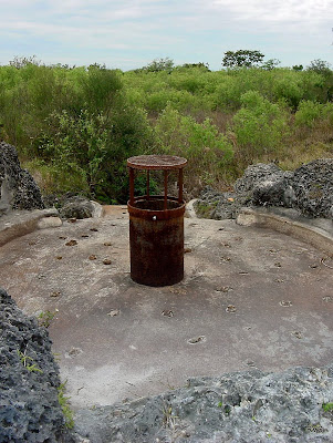
I started work at the FMB and I am staying in my Scotty camper. For now I am coming home on the weekends. The mosquitos are bad BTW. The Loop Road is closed in the center portion. I found the rocks surrounding the well in disrepair..
Shortly after posting the pictures of the FMB atesian well, complaints started coming in. There are no plans of capping this well at this time that I know of. A nice Miccosuki maintenance worker cleaned the area and I rearranged the rocks. I put a valve on the well pipe so it can be shut off to appease the complainers and also to limit puddling and mosquito larvae infestation in the immediate work area.. It has some leaks but I slowed it down considerably. Hopefully that will stop the complaints. I dont see how it can be harming anything.
There has been much speculation on the origin of this artesian well. The latest information I gathered seems to point in the direction that this may be one of Garald Parkers USGS test wells from the late 40's. He used 6 inch casings and drilled wells throughout South Florida in an attempt to solve the problem of salt water intrusion.
"So we (Garald Parker) had found then the sources and the mechanisms that were causing Miami and the whole area of this coastal ridge, that was losing their fresh water supply chiefly because the Everglades were being drained purposefully, and the coastal ridge with its fresh water lands, was being drained as an unplanned result." You can read his interesting 1989 interview here. http://sofia.usgs.gov/memorials/parker/usgsinterview.html
- "In 1940, Parker began his career as a hydrogeologist when he made a cross-country trip to help save the water supply of Miami, Florida from saltwater intrusion. Parker developed protective measures to save well fields and also from 1940 to 1947 identified and named the Biscayne Aquifer, the Floridan Aquifer and defined the geologic structure of southern Florida. Parker was also a mentor to Marjory Stoneman Douglas on the water of the Everglades for her 1947 book, The Everglades: River of Grass. Parker also discovered the Peninsular Florida Hydrologic Divide which results in the southern portion of Florida being entirely dependent on rainfall for its freshwater." (Wikipedia)
-
-
An interesting link on saltwater intrusion and the Ghyben Herzberg Relation.
"Water is life; without water, we have nothing. Without water, we die."
http://www.amyhremleyfoundation.org/php/education/features/Aquifers...
Without the Everglades, we have no water, we have no life; without the Everglades we have nothing.
-
-
I believe the reason for capping artesian wells is saltwater. The freshwater "lens" is deeper inland but these wells are deep enough that they may enter the saltwater table which lies beneath the entire South Florida peninsula.
The saltwater could contaminate the surrounding area if left to flow unabated. I dont believe there is any salt in the FMB artesian well but maybe it could be tested. Some interesting reading. http://sofia.usgs.gov/publications/papers/wsp1255/PDF/wrsf_1255/pdf...
- ‹ Previous
- 1
- 2
- 3
- Next ›
About
Welcome to
Everglades Exploration Network
© 2025 Created by Keith W.
Powered by
![]()